It’s a bit of a run out of Scotland’s west coast centres, says JOHN LIDDIARD, but much remains to be seen on this rarely dived casualty from a storm in 1951. Illustration by MAX ELLIS
Last year’s Wreck Tour of the Shuna (February 2003) left me with something of a problem. The series has been averaging more than a wreck each year from the very popular Oban and Sound of Mull area, and with the publication of the Shuna we had run out of wrecks!
So I started asking around: which wrecks suitable for a Wreck Tour were there a bit further afield? Recommendations for the Tapti at the south end of Coll came from various sources, though at 35 nautical miles from Lochaline it was further out than I had originally sought.
So I borrowed a RIB from Humber and some numbers from Phil Robertson at Lochaline Dive Centre, and set off to sketch it.
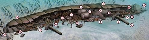
Finding the Tapti is easy enough. The GPS numbers identify the rock called Eilean Iomallanch off Soa Island and, if they are not right on top of the wreck, a little searching in and out with an echo-sounder will soon show the wreckage at the bottom of the slope, about 50m out from the rocks. The boilers give a nice distinctive wreckage echo, so that is where our tour begins (1).
The wreck has collapsed to starboard, bows out to sea, leaving the keel against the rocks and the deck laid out flat on the sand. The boilers have rolled out of the hull, the orientation of the fire-holes showing that they are upside-down (2).

Almost off the wreck on the starboard side, a cargo-winch (3) indicates the location of a hold between the wheelhouse and the stoke-hold and engine-room. The short mast serving the derricks for this hold is easily visible on old black and white photographs of the Tapti before she sank.
Continuing forward, the wheelhouse has collapsed and folded to leave the T-shaped open bridge and wings that would have formed the wheelhouse roof almost level with the seabed (4).

The railings round the bridge wings are still in place and are prime real estate for yellow dead men’s fingers and small anemones.

Staying to the starboard side of the wreck and crossing the area of number 2 hold, the boundary between the forward holds is marked by a cargo-winch (5), then a very substantial mast. This has pulled over with it the deckhouse that served as its foundation (6). Another cargo-winch lies on the other side of the deckhouse (7).
Rather than continue along the wreck, a diversion to the top of the mast will lead to the starboard anchor-chain trapped under the end of the mast (8) which leads out in a short loop and back to the bow. By some strange pattern of sinking, however, the anchor itself (9) rests against the side of the anchor-winch (10).
Contrary to the description in all the guide-books, the bow rests on its starboard side, the port side rising 5m from a 20m seabed. All the books note the bow as standing upright with the tip pointing to the surface, but either someone diving the wreck many years ago made a mistake and the erroneous report was propagated, or the bow has fallen to this orientation more recently.
Considering that the line of the Tapti’s keel is pretty much straight and unbroken, I am inclined to think it has been like this since soon after the ship sank, and that a diver many years ago was suffering from 20m narcosis.
Sticking out into a gentle current flowing outside the bay, the tip of the bow is home to a thick colony of plumose anemones and more dead men’s fingers. On the upper port side of the bow, the port anchor remains secured firmly in its hawse-pipe (11).

Having explored the side of the wreck closest to the seabed, the simplest route back to the boilers is straight along the “top” of the port side of the hull (12).
Aft of the boilers, the guts of the engine-room are now beneath the collapsed hull (13). There is enough solid machinery inside to hold the hull up and provide a simple but low swim-through, giving access to the crankshaft and connecting rods from the steam engine.

On the opposite (starboard) side of the deck, a pair of boat-davits are arched into the sand (14) with another cargo-winch between them.
Inside the aftmost of the pair of davits are two substantial curved tubes with rolled ends (15). Original photographs of the Tapti show some ventilators in this location, so perhaps they are part of these units, though they are much thicker and heavier than I would expect ventilators to be.
Also, if they are part of the ventilators, what happened to the rest of them?
Continuing towards the stern, we are now in the area of the aft pair of holds, separated by a mast and deckhouse (16) that is identical to that between the forward holds, then another cargo-winch (17).
At the stern a large deckhouse containing cabins has collapsed, the steel roof now resting between the stern deck and the seabed (18).
The stern itself is rather narrow and almost pointed (19), twisted by the keel so that the deck is just short of upright. The remains of the steering-gear are just visible inside if you peer through gaps in the deck. Below the stern, the rudder has been removed and the propeller salvaged (20).
With the depth of the Tapti ranging from 20m to as shallow as 13m, a dive is unlikely to get into decompression. With typical west coast of Scotland visibility, it should be easy enough to navigate forward and ascend the shotline.
ON THE ROCKS
Taking a ship in ballast from the Mersey to the Tyne around Scotland was never the best of voyages. In January 1951, it proved too much for the motor vessel Tapti and her skipper Captain Coney, who had orders to pick up a cargo for India at Tynemouth.
The 125m-long Tapti made good progress until 17 January. That’s when she found herself short of the Minch and in the middle of a violent rainstorm, with hail driven by a south-westerly gale wiping out all visibility, writes Kendall McDonald.
The onset of night made things worse for the captain, his officers and the crew of 60 Indian and Chinese seamen. They continued, as they thought, on course in the black-out, but were in fact running inside Tiree, with Mull to starboard. Suddenly Tapti struck rocks on the east shore of Soa Island off the southern end of Coll.
The impact made by the 6,609-ton steel ship was colossal, and though Captain Coney ordered “full astern”, Tapti would not come free.
Swell after swell from the south drove her further on, until finally the waves span her round, driving her stern higher on the rocks. Captain Coney admitted defeat, and sent Mayday calls to Malin Head radio station.
The Tapti stayed on the rocks all night. By dawn the rescue ships around her consisted of both Mallaig and Barra lifeboats, two frigates and two trawlers, but there was little that they could do. She settled deeper and listed more and more.
Soon that list had reached more than 60°, and her captain ordered “abandon ship”. Every member of the crew was soon scrambling down nets and into the lifeboats, which took them to Tobermory.
Tapti stayed on the rocks for four days before a southerly gale gave her another battering. It was too much. During the night of 21 January, she rolled off the rocks and sank in deep water. Salvage work soon began, and continued for several years whenever the weather allowed.
TOUR GUIDE
GETTING THERE: Follow the A85 towards Oban. For Lochaline, turn right across the Connel bridge just before Oban. Follow the A828 north past Tralee to take a short ferry across Loch Linnhe at Corran, then head south again on the A861 and A884.
DIVING & AIR : Lochaline Dive Centre.
ACCOMMODATION: Hostel at the Lochaline Dive Centre. Oban tourist information
TIDES: The Tapti can be dived at any state of the tide.
HOW TO FIND IT: The GPS co-ordinates are 56 33.769N, 6 37.885W (degrees, minutes and decimals). The location is within 50m of the rocks, with the wreck lying in line with the rocks, bows to the east.
LAUNCHING : The ferry slip at Lochaline is ideal for launching, but take care not to obstruct the ferry. There are alternative slips in Oban and on Mull.
QUALIFICATIONS: The Tapti is shallow enough for Open Water divers, though the exposed nature of the site is best suited to those with more experience.
FURTHER INFORMATION: Admiralty Chart 2171, Sound Of Mull And Approaches. Ordnance Survey Map 46, Coll & Tiree. Ordnance Survey Map 49, Oban & East Mull. Argyll Shipwrecks, by Peter Moir & Ian Crawford. Shipwrecks Of The West Of Scotland by Bob Baird.
PROS: A shallow and rarely dived wreck that retains a lot of structure.
CONS: A long boat journey.
Thanks to Tony Jay, Victoria Jay, Tim Walsh, Rachel Locklin, Phil Robertson & Andy Jameson.
Appeared in Diver, May 2004